


I’M NOT A SUPERSTITIOUS GUY, BUT REALLY, I SHOULD HAVE KNOWN. I’m no meteorologist either, but after 35 years of living in the high country, even I knew that depending on how it set up, the weak El Nino the long-range forecasters were predicting could mean dry as much as it could mean wet. Still, after three years of drought, the winter of 2015 had to be a wet one. So I bought some of those winter-only tires, you know, the ones with the soft sticky rubber that wear out after about 10,000 miles of running on dry pavement. It was economics, really. What with gas prices pushing $5.00 a gallon here in our little resort town, I figured that getting the 40-mile-per-gallon Corolla out our long snowy driveway would save us from driving the fuel-hungry truck all the time. Certainly, after three of the drier winters on record, it was bound to be a wet one. A normal backcountry snowpack would even justify mounting up the skis that have been waiting to kiss some powder for three seasons.
But really — I should have known.
At the same time, after four dry years, there isn’t really much for the local skier to complain about. Sure, business is down, but Mammoth Mountain has been pumping copious amounts of groundwater up to 9,000 feet and turning it into the magic powder that drives the local economy. The skiing up on the Mountain has been quite good, or so I’m told. And the string of lights threading a path up Highway 395 on Friday nights, the “Mammoth Milky Way,” suggested that tourist dollars were making their way into town. But down here at the 7,200-foot level, I never needed to lift a shovel or clear snow from the solar panels. And the plethora of hot sunny days warmed the house to the point that I needn’t put up any wood for next year. The silver lining.

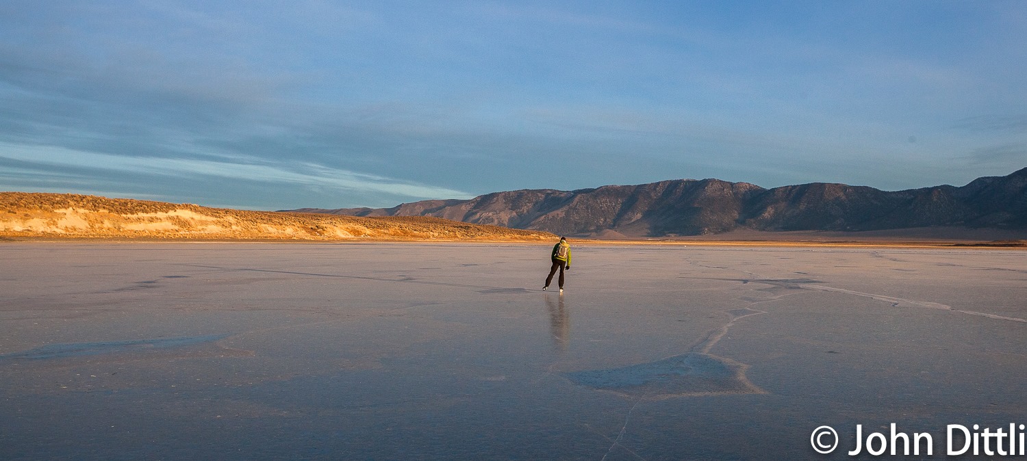
But taking those little amusement rides up The Hill so I can slither back to the bottom just isn’t my thing. I’m not knocking resort skiing mind you; I’m just more of a backcountry guy. As a wise man once said: “A bad day in the backcountry is better than a day riding a lift.” And while there could well be some truth to that, the real truth is that the last four winters have been challenging in the backcountry. And that’s OK, because I’m always up for a challenge. No snow? I’ll go backcountry ice skating, at least until the first “dump” drops three inches of snow and covers the ice. Three inches… really? No worries, this is the Sierra and the winds will blow and maybe those few inches will fill the gullies. So we hike in a few miles through brush and talus dusted with a fine little icing of powder in search of the couloirs. We find them, we ski them, we don’t hit too many rocks, and we are glad we didn’t use new skis.

I feel fortunate to have lived in the Sierra as long as I have. During the past three-and-a-half decades I’ve had the opportunity to shovel my way through some huge winters, including the mother of them all: the El Nino of 1983. There have been some dry years along the way as well, but there were never any that kept us from skiing those little-known powder pockets guarded by the locals, even during the droughty winter of ’77 that preceded my arrival in the Sierra by a couple years. Tale even has it that there was a sign on the way out of Mammoth that stated, “Turn the lights out when you leave.” Even as paltry as that year was, the legendary guide David Beck apparently toured in the southern Sierra.
Twenty years ago, I stumbled upon an opportunity to work as a snow surveyor for the California Department of Water Resources (DWR). The local Eastside team was short-handed and I had nothing but time. When I learned that the job required skiing into the backcountry for 10 to 12 days at a time, I thought, “I can do that.” Though I’d skied the backcountry for years, the little I knew about the job came from my reading about my idol, Orland Bartholomew, who was one of the Sierra’s first surveyors in the ’20s, and also a backcountry ski pioneer whose winter traverse of the John Muir Trail is chronicled in Gene Rose’s High Odyssey.
An old surveyor once stated that there is no glory in the job, that “it’s just one foot in front of another.” Indeed, the job can be brutal at times, and I’ve broken trail through knee-to-waist-deep snow days on end. There are, however, less unpleasant aspects to the occupation, and I’ll just leave it at that. Or use your imagination. Or maybe the editor will include some photos. Suffice it to say that for a couple of weeks each month we load up the packs and head into the backcountry to sample snow, whether there is plentiful inventory to measure or not.
Enlarge

John Dittli
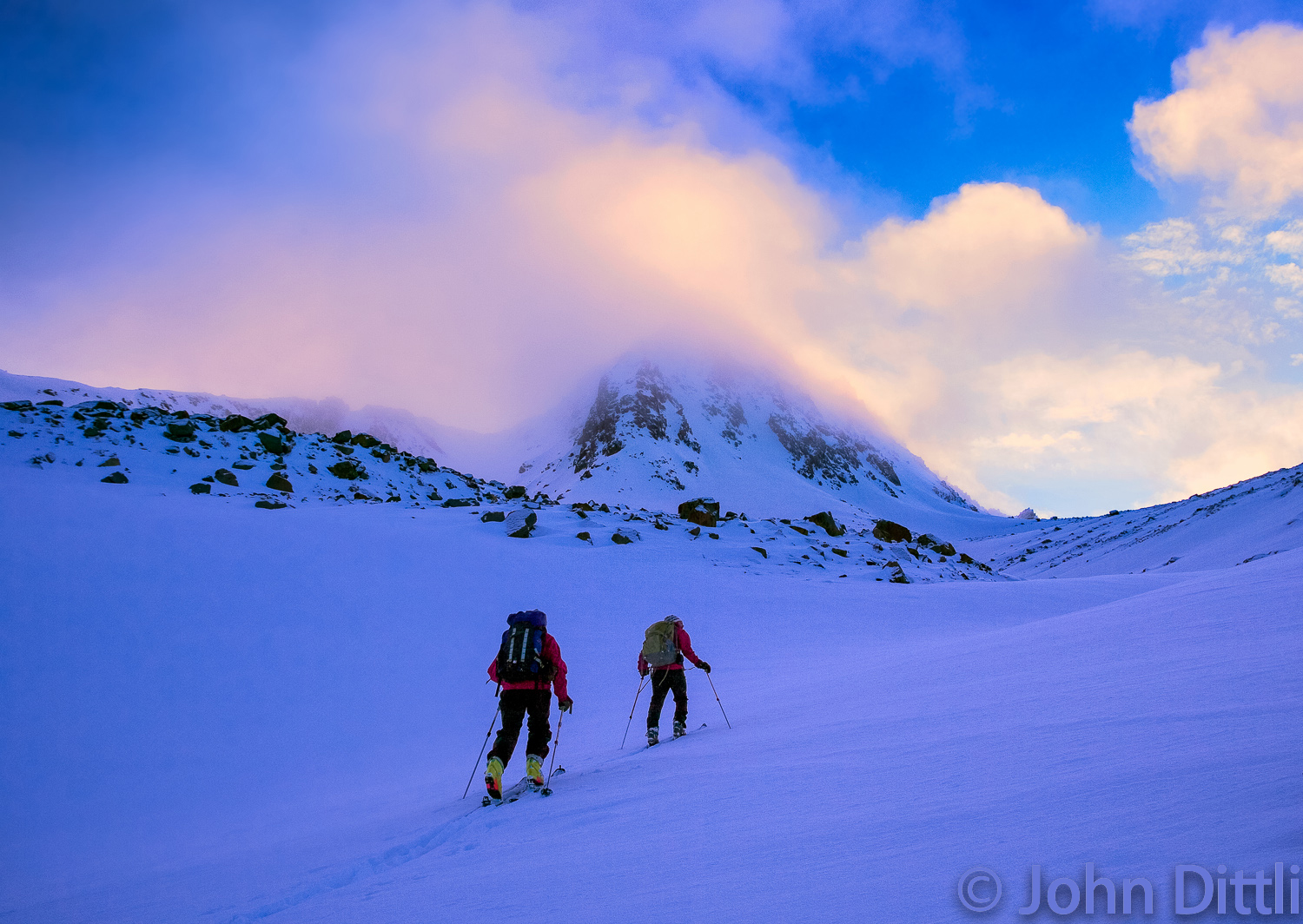
Our Eastside team of nine surveyors covers the High Sierra from east of Yosemite to a little south of Mt. Whitney; it’s a nice chunk of landscape. We are an eclectic group of veteran explorers with flexible lives that allow us to drop everything for the first couple of weeks each month during the heart of winter and spring, February through May. Splitting into two teams of two or three, one team takes the upper Kern River Basin, while the other gets the big Eastside passes. We then have a ten-day window to collect data and transmit them to the Big Kahunas at the DWR. Usually by the first survey at the end of January (known as “Feb one” in snow survey speak) several feet of snow have blanketed the high country, and we already have days, weeks, or even months of skiing under our boards.
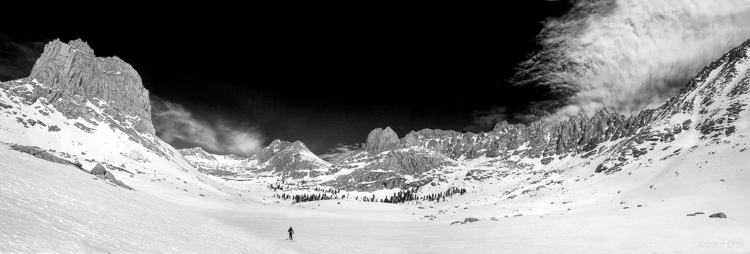
But by the time the February survey came around this year, there was barely a foot of snow in the higher elevations of the southern Sierra, and I had more time on ice skates than on skis. All the same, I was happy to receive my assignment to survey the Kern River snowshed, which would require twelve days of travel through Sequoia National Park, from Horseshoe Meadow to Forester Pass and back. I was doubly pleased to be partnered with the fit, enthusiastic, and competent Ann Klinefelter, a good friend.
Packing for a survey has become second nature: we grab skis, skins, sampling equipment, and go. But this year, unsure of the conditions, we added running shoes. Wise move. We skied just 40 miles of shallow winter snow, all the while breaking trail for two guys who would eventually complete the first winter thru-hike of the Pacific Crest Trail. The other 30 miles we hiked. We wore shorts.
Needless to say, February passed with scant new snow. During the March survey we found about a foot of powder over rocks. “April one” is ordinarily the pinnacle of the water year, the survey that historically has us finding the richest snow-water-equivalent (SWE) in the snowpack, and the April findings are the gold standard, because they determine how much (or how little) water will flow to farms and fish and the huge coastal communities of the Golden State, which is the world’s seventh largest economy.

I was scheduled to visit the Sierra passes for the “April one” survey, and I could barely contain my somewhat sick sense of excitement to see how close to April ‘77 this year might be. From Virginia Lakes in the north to Kearsarge Pass in the south, we sample four separate river drainages from the east: the Walker, Owens, San Joaquin and Kings. Surveying the passes involves several two-to-three-day out-and-back excursions across the crest to the west side, and the data provide a broad spectrum of conditions in the high reaches of the High Sierra. To this point, the winter of 2015 had not only been dry, but inordinately hot, and the snowpack had been on the wane for most of March; even ’77’s meager snowpack had lingered longer than that.
I had teamed with Kevin Klinefelter (Ann’s husband) and we were again faced with the question of how to navigate the bony terrain. Although I had recently skied some pretty fine lines thanks to wind-transported snow, after skiing the backcountry for over 40 years, we were through with lugging skis and boots on our packs just to tiptoe across islands of rock in an attempt to link ever-shrinking patches of snow. We again opted for running shoes, this time with short snowshoes for backup. Prior to the survey, anticipating parched earth and piqued by the aforementioned morbid curiosity, I had written a small note on the margin of my field book: North Lake 1977: 9.1” snow, 2.6” water.
Enlarge

John Dittli
First up was Piute Pass. As we drove up Highway 168 out of Bishop, the grinding of winter tires on bare pavement mocked us, and their whir echoed across the brown, snow-free slopes of the front range. At 8,500’, we arrived at the gate to North Lake, the usual point of winter closure. Normally we would start the tour here, skiing the three miles of road to the summer trailhead and our first measurement course, but this year we drove the three miles instead of skiing them, and parked the car at road’s end. We sauntered to the snow course at North Lake, elevation 9,300′. In a normal year, we’d expect to measure the equivalent of 10 inches of SWE at North Lake, but not only was the course free of snow, the meadow grasses were beginning to sprout, and the dismal reality of the bleak snowpack started setting in: North Lake 2015: 0” snow, 0” water. As we hoofed it up the dry trail, we saw a ptarmigan, stark and vulnerable in its white winter plumage against the dry landscape, easy prey for a raptor or coyote. In an hour we reached our next course called East Piute, at 10,800′. Of the eight sample points at East Piute, three were completely dry. In total, we measured 7.1 inches of snow and 2.6 inches of water, just 84 percent of 1977. And so it went over Piute Pass, Bishop Pass, Kearsarge Pass and Virginia Lakes: the survey data were just half of the April measurements from the infamous winter of ‘77. These high-altitude courses compared miserably to 1977, but so too did the lower-elevation courses, which are 2,000-feet lower throughout the range. In 1977 these courses had snow, but this year they had none.
Enlarge

On March 27, 1983, Minaret Summit, the 9,265-foot high point of the road from Mammoth Mountain to Red’s Meadow, was buried under 206 inches of snow and 84 inches of water. That’s seven feet of water covering the entire landscape. This year we rode our bicycles over the virtually snow-free Summit en route to a course at Devils Postpile. As we pedaled across dry asphalt, I reflected on a book I had recently read, The West Without Water, by B. Lynn Ingram and Frances Malamud-Roam, a university researcher and an environmental biologist, who compiled centuries of tree ring data to depict a history of a climatically bipolar West marked by severe, prolonged droughts and massive floods, with winters so parched that trees rooted and grew for two centuries in the dry sump of Tenaya Lake and nearly 80 feet below the average water level of Lake Tahoe. When reading the book it had struck me that the Sierra Nevada’s snow data from the last 75 years was insignificant compared to the data from the geologic record. The winter of 1977 was just a blip in time, as will be 2015. Are we in the throes of a 30-year drought, or will next year be “normal?” For that matter, in light of this radical climatic flux over geologic time, how does one characterize “normal,” anyway?

Sitting in the green grass of Reds Meadow, it feels like a summer day. I think about the future of California and the American West. The climate will change, we will be forced to adapt, and we can only hope that ecosystems will withstand the two-fold stress of climate change and the accompanying cultural pressures. Mountain resort communities will undoubtedly be forced to reinvent their revenue strategies, and those of us who live in and near them may find ourselves questioning our tenancy of very dry ground. The climatic events here in the Eastern Sierra should behoove us to break from our anthropocentric world-views, but where to begin? We might start with understanding the realities of the distant past while we consider how to live in the present, and accordingly, make suitable plans for the future. A slight, cool breeze rises from the San Joaquin River, and my thoughts are broken by the wistful song of a Hermit Thrush echoing through the Red fir. Devils Postpile 2015: 0.0″ snow, 0.0″ water.

John Dittli is an award-winning outdoor photographer and writer who has climbed, skied, and explored the inner reaches of the American West. He and his wife, Leslie Goethals, live in the Eastern Sierra in a hand-built, off-the-grid home occasionally visited by a host of Great Basin rattlesnakes. Check out John’s website for more about his photography and his book, Walk the Sky: Following the John Muir Trail.