


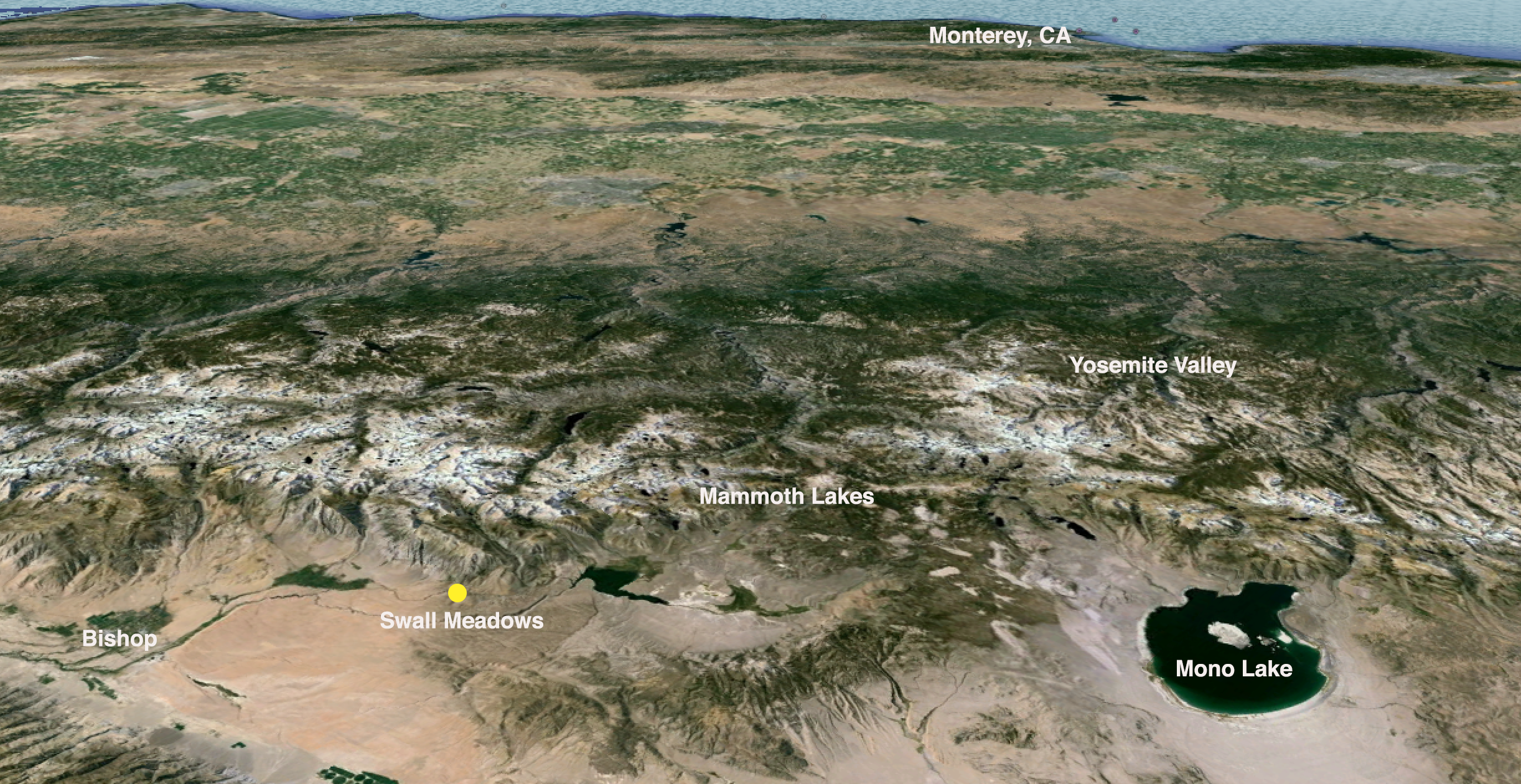
ON THE EVENING OF FRIDAY, FEBRUARY 6, 2015, a wildfire swept through the small communities of Paradise and Swall Meadows, located along the eastern escarpment of California’s Sierra Nevada. Fueled by extreme drought and 100-mile-per-hour winds, the fire raced through the tinder-dry brush and pinyon pine forests, burning 40 homes and 7,000 acres. The inferno would become known as the Round Fire.
These are dry times with wild, unpredictable weather. Springtime generally visits the high plateaus of the Eastern Sierra come April or May, but it has come much earlier these last four dry years. There have been other droughts, but this one has been especially hard on the land. My story is just one of many that came from the Round Fire. Although my home and family were out of harm’s way, others in similarly situated communities here and across the American West haven’t been as fortunate. Ours is an all-too-common narrative as dozens of wildfires burn throughout the country on any given day.
We bore witness to a loss of innocence. What lessons can we learn?
Buffeted by gale-force winds, I positioned my camera on the lee side of the truck, mesmerized and sickened as I watched flames consume the homes of good friends: teachers, woodworkers, scientists, guides, photographers. As I braced my body against the gusts and pressed the shutter, I feared for their safety and wondered about their future. As nightfall descended upon the Sierra Nevada I noticed an eerie orange glow hanging above the small community of Round Valley.
I had been teaching a photography workshop with fellow colleague, Jerry Dodrill, at Bishop, California’s Mountain Light Gallery founded by the late photographers Galen and Barbara Rowell. Graced with sweeping views of the Sierra to the west and the White Mountains to the east, the dramatic geography surrounding Bishop makes it a perfect basecamp for a landscape seminar. That morning we had been in the Alabama Hills, and the group captured low-angle winter light as it raked across the ridges of Lone Pine Peak and Mt. Whitney. We had a busy day planned with afternoon print critiques followed by an evening session at Mono Lake, about two hours to the north. News of a small fire at one of the local ranches northwest of Bishop trickled in to us in the early afternoon, but our attention was with our clients. As the day progressed, clouds boiled high in the sky above. And then came the winds.

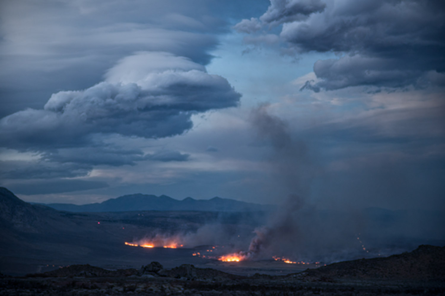
The California Highway Patrol issued SigAlerts for the northern parts of Mono County, closing U.S. Highway 395 to all high-profile vehicles and campers as dust clouds from gale-force westerlies strafed the parched valley below. The Mono Lake Web Cam showed the lake churning with white caps as plumes of sand and soil rose from the exposed shorelines. We scrubbed our plans for the Mono Basin. We wanted a foreground, the element Rowell described as “combining Earth with sky,” so we headed to Buttermilk Country, a boulder-strewn upland just west of Bishop nestled against the backdrop of Mt. Tom and Basin Mountain. By the time we arrived, the entire Owens Valley skyline, north to south, had filled with dramatic lenticular clouds. As we captured images we noticed plumes of smoke and numerous spot fires below in Round Valley, a small bedroom community outside of Bishop. The small fire we heard about earlier had spread, but it seemed like it would soon be contained. It was 6:45 and getting dark fast.
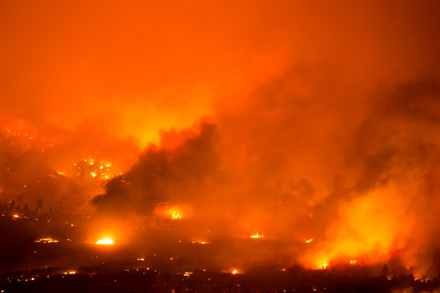
Jerry and I adjourned the workshop for the evening after a quick dinner with our clients. We grabbed our camera gear and set out to explore the blaze that was producing the surreal light glowing against the Sierra. We drove fifteen miles to an overlook on the outskirts of town, parked the truck, and stood in amazement. Everything seemed to be on fire. A wall of flame thundered through the brush and trees toward the communities of Paradise and Swall Meadows, engulfing everything in its path, kicking light into the lenticulars high above. The huge granite towers on the Wheeler Crest loomed silent and ghostly, their outlines rising through the smoky mist like sentinels. The pungent odor of burning sage and pinyon pine filled the air.

As I documented the gruesome scene from afar, I prayed the fire looked worse than it really was. Glassing the community through my telephoto lens, however, I saw flames leaping off rooftops and pouring through windows. The explosions of propane tanks and combusting houses pierced the night air. These weren’t the homes of strangers; they were the homes of dear friends who share a love for adventure and a respect for the land, and our relationships are bound by decades of climbing, backcountry skiing and mountaineering together.
The orange glow in the sky could be seen from miles away, and word of the fire spread quickly to the adjoining communities. I hurriedly exchanged texts with my wife Suzanne, who was at our home in Crowley Lake, just 10 miles to the northwest. “Should I come home now? Are you okay?” I was prepared to drive the back roads home to skirt the highway closures. Although she felt confident our home would be safe, Suzanne packed the car with a few essentials: computers, hard drives, photo albums, clothing, food and water. She fed me Internet updates and shared the news that our good friends, Dennis and Jeanne Oakeshott, had made it to safety, escaping with their dog Migo and their kitty Lupe, but nothing more. Meanwhile, I relayed the accounts of what I was witnessing. Suzanne told me that the residents of Sunny Slopes and Tom’s Place, just a few miles from our home, had been issued voluntary evacuation orders. At this point, it was about 10:00 pm.

A few hours later, Jerry and I returned to our hotel and processed photos into the early morning. By enlarging the photographs with my laptop, I could see in detail what I could only glimpse through the haze, and the fiery images of destruction haunted me, especially because I couldn’t make out whose homes had been spared. We posted several images to Facebook and by dawn we were deluged with media requests from across the country.
We met our group and drove to the Owens River as the the sun’s first rays crept over the White Mountains. Painterly light washed over the river basin and the air was thick with moisture from a rain that arrived sometime in the night. The wet sage smelled sweet, the desert was alive, and there wasn’t a breath of wind. You wouldn’t have known a fire had raged just a few hours ago and a few miles away.
Meanwhile, a tense waiting game began for the evacuated residents of Swall Meadows — all of whom had escaped unharmed — and many waited by police tape to learn the fate of their properties.Emergency personnel weren’t sharing much information. There were still hotspots and flare-ups and trees and homes still smoldered. Dennis and Jeanne hiked out to a ridge with binoculars and confirmed their worst fears: their home was gone. They saw concrete cracked by the heat of the fire, twisted metal, melted glass and crumbled drywall that looked like cottage cheese. Many other homes were leveled, too.

Finally, the news filtered out through the television networks: 40 homes lost. Paradise, the community just downslope of Swall, had been in the direct line of the fire as it marched up the hill, but at the last moment, the fire suddenly shifted and blew toward the Sierra, weaved through the forest toward Swall Meadows, and razed homes while sparing others. In a cruel twist of fate, the wind turned once again, this time to the northeast, taking out houses one by one. Half of the property in Swall Meadows had become nothing more than memories.
That evening, my wife, along with longtime friends Jim and Sue King, owners of Rock Creek Lakes Resort, hosted a dinner for the homeless Oakeshotts. We expected a somber and tear-filled evening, but the night was filled with laughter, storytelling and planning for the future. Sadness and the sobering reality of the day’s events lay just beneath the surface as Jeanne said, “I don’t even own a fucking toothbrush or a clean pair of underwear for tomorrow!”
By Tuesday, the Inyo County Sheriff’s Office lifted their barricades and allowed residents to return to their homes, or what was left of them. Dennis was one of the first to venture back into Swall Meadows, anxious to start anew.

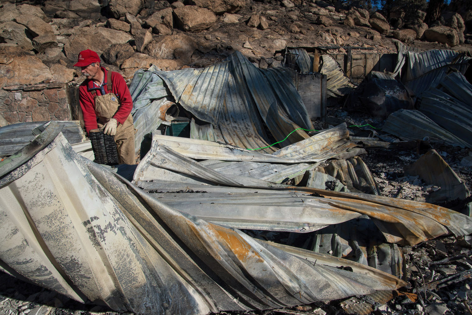
Word had spread through the Eastside grapevine: “The Oakeshotts need help.” I drove down the following day. By the time I arrived at the remains of the Oakeshott’s home, a small crowd had already assembled. Here were good friends who had unquestioningly abandoned their lives to lend a hand. A contractor soon arrived with tools and machinery, and the local lumber yard loaned their excavator, but most of us carried little more than gloves and respirators. Dennis, a furniture maker and artisan, had built a showpiece home. Now it was 10 inches of debris below a pile of twisted corrugated metal roofing. Some people cut and cleared away the roof, and others sorted through the crumbled drywall and shattered glass for scraps of steel from window frames, drawer slides and box springs, all bound for recycling. I was flooded with fond memories and overcome with emotion when, wading through calf-deep ash, I came upon a buried treasure: a box of Kodachrome transparencies of a long-ago adventure on El Capitán’s Salathé Wall, in Yosemite Valley.
“Hey Dennis, we really like what you’ve done with the place,” someone yelled, breaking the tension. We all laughed – even Dennis. I imagine we all felt some kind of survivor’s guilt, but it sure felt good to help them pick up the pieces of their lives. I’m inspired by this resiliency of the human spirit, the strength and tenacity of these old friends.

Three months later, I walked alone through the ash, less than a mile from where a downed power line sparked the blaze. The mountains were shrouded in clouds from an incoming storm and a light snow fell. My cheeks stung from the wind and damp cold, and the ground, thinly crusted over from the flames, crunched beneath my feet. Granite boulders had popped open from the fire’s heat, and the surface of the rock peeled like onionskin. Skeletal silhouettes of Jeffrey pines, water birch, locust, and willow stood along Rock Creek, with the ramparts of the Wheeler Crest looming in the background. I found the remains of a deer – a sprinkling of bone shards here and there, and larger, intact pieces: a pelvis, a femur. It had been a young male, grazing, perhaps, when the smoke felled it. You could tell by the small antlers still attached to the skull.
A forest fire in February? Nobody saw it coming.
As the human spirit is resilient, so is the earth, and it too is healing. Deer have returned, attracted by the tender grass shoots that poke through the charred earth. Indian Paintbrush and tiger lilies rim Rock Creek, which gurgles and meanders through the blackened desert. Peals of laughter fill the air, and smiles lighten faces once smudged with soot and tears. Within weeks of the fire Dennis and Jeanne submitted building plans to Mono County, and they’ll soon start raising walls. Dennis replanted his garden.

The summer months always bring a threat of wildfires, but with four years of drought and volatile weather, we have moved into a 12-month fire season. Today the skies of California are choked with smoke from fires burning throughout the West. The air has grown heavy and amber in color, obscuring the the sharp ridge lines on the nearby peaks and ridges. Sometimes specks of white ash float gently from the sky, coating the plants in our yard. The air is tinged with the smell of soot from the trees burning high on the Sierra’s western slope.
I hope for cooler months and the prospect of snow. And I wonder what this winter will bring.


More photos of the Round Fire by Jim Stimson.
 Jim Stimson’s photographs of the Western landscape are published in a wide variety of books, magazines and calendars. He has authored a number of articles and his work has appeared in Smithsonian, Orion, Backpacker, Sierra, Earth, Wilderness, Outdoor Photographer, Camera and Darkroom and View Camera magazines. His images have been featured the calendars of The National Audubon Society, The Sierra Club, The Nature Conservancy, The American Museum of Natural History, Browntrout, and The Mono Lake Committee. Stimson was presented the Ansel Adams Award for Photography by the Sierra Club and his book, Mono Lake: Explorations and Reflections, was chosen Book of the Year by ForeWord Magazine. He has also been honored by the Roger Tory Peterson Institute, The Banff Mountain Film and Book Festival, and the Maine Photographic Workshops. His fine-art prints are carried by Mammoth Gallery in Mammoth Lakes California, Mountain Light in Bishop, California and the G2 Gallery in Venice, California. His images have been collected and exhibited throughout the United States, Japan and Europe.
An avid backcountry enthusiast, Stimson has made his home in the Eastern Sierra since 1975. He lives with his wife Suzanne and their two children in Crowley Lake, California. See more of his work here, at Jim Stimson Photography.